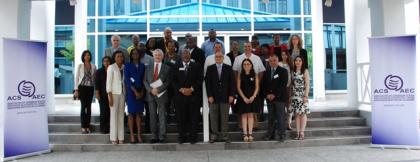
ACS and the UWI sign MOU on Geospatial Information Management

NR/ 007/2015

Port of Spain, Trinidad and Tobago, March 26th, 2015- The Association of Caribbean States (ACS), the University of the West Indies, St. Augustine Campus (UWI), Mexico’s National Institute of Statistics and Geography (INEGI) and the Embassy of the United Mexican States in Trinidad and Tobago convened to sign a Memorandum of Understanding (MOU), as they resolve to join efforts towards the achievement of the objectives of the “United Nations Committee of Experts on Global Geospatial Information Management” initiative (UN-GGIM) and of the “Caribbean Platform of Territorial Information for Disaster Prevention” PITCA project. These projects are funded by the Government of Mexico.


In his capacity of Principal of the St. Augustine campus, Professor Clement Sankat declared that the signing of the MOU is historic as projects like PITCA are transformative as they involve the incorporation of countries of different languages. He further posited that this is a wonderful partnership because assistance is needed in a range of areas including natural resource management.


The PITCA initiative intends to establish a platform to provide territorial geospatial information, from national as well as regional sources, with the aim of reducing vulnerability in the region through the analysis of risks, strengthening decision-making for the development of planning policies, design and infrastructure construction, housing, reduction of agriculture vulnerability, among other strategic sectors.


Complimentarily, the UN-GGIM aims to promote the development of Spatial Data Infrastructure in eleven countries in the Caribbean, to strengthen the generation, use and sharing of geospatial information.


Within this framework, the ACS also hosted a Workshop to familiarise Caribbean counterparts with the PITCA initiative, introduce the 2015 work plan and its components and simultaneously identify synergies with the UN-GGIM. Principal activities included presentations by the Facilitators and participants, who also provided information on the status of their respective countries as it relates to availability and institutional arrangements of spatial information


The Workshop gathered participants from The Bahamas, Grenada, Jamaica, Mexico, Saint Lucia, St. Vincent and the Grenadines, Trinidad and Tobago, Turks and Caicos and the Virgin Islands. Representatives from the Caribbean Disaster Emergency Management Agency (CDEMA), Glo Tech Vision, National Centre for Disaster Prevention (CENAPRED), Urban and Regional Information Systems (URISA) and the World Bank were also in attendance.


Participants commended the ACS for this initiative stating that it seeks to reduce the Geospatial Data Infrastructure gap in the region, with respect to the other countries of the Continent.

About the ACS

The Association of Caribbean States is the organization for consultation, cooperation and concerted action in trade, transport, sustainable tourism and natural disasters in the Greater Caribbean. Its Member States are Antigua & Barbuda, The Bahamas, Barbados, Belize, Colombia, Costa Rica, Cuba, Dominica, Dominican Republic, El Salvador, Grenada, Guatemala, Guyana, Haiti, Honduras, Mexico, Jamaica, Nicaragua, Panama, St. Kitts & Nevis, St. Lucia, St. Vincent & the Grenadines, Suriname, Trinidad & Tobago and Venezuela. Its Associate Members are Aruba, Curacao, (France on behalf of French Guiana, Saint Barthelemy and Saint Martin ), Guadeloupe, Martinique, Sint Maarten, (The Netherlands on behalf of Bonaire, Saba, and Sint Eustatius ), Turks and Caicos.