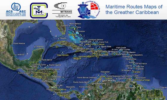
Maps of Maritime Routes of the Greater Caribbean

CONTEXT
The liberalisation of markets, the numerous bilateralor multilateral agreements in force worldwide and the emergence of several developing countries have led to a significant boost in international trade and, in particular, the trade in goods, which is also facilitated by improved transport techniques.
Today, it is estimated that 90% of the goods circulating worldwide are transported by sea, placing maritime trade at the heart of the issues related to economic growth.
Since the Greater Caribbean cannot escape the globalisation process, the development and efficiency of maritime transport is a key issue in regional development.
This issue is even more crucial for the small islands in the Caribbean.Given the high degree of openness of small economies, the island States of the Caribbean import the vast majority of goods required for their consumption. Moreover, many of the goods produced locally rely on the importation of raw materials for their production.Owing to its geographical location, trade in goods in the region occurs primarily by sea. However, the Caribbean is faced with very high transportation costs (which, according to estimates, are on average three times higher than in other regions). The cost of transporting goods is one of the barriers to trade, which reduces the profitability of exchanges and, further, impacts the entire economy (development and survival of companies, job creation, effects on consumption, etc.).
A large number of factors influence the cost of maritime transport, such as: the type of vessel, distance, but also the characteristics of the goods (weight, fragility, etc.), quantity transported, route (quality of infrastructure, frequency of passage, transportation opportunities on the return trip), etc.Given the size of their economies, the inadequacy of economies of scale constitutes, for the island Caribbean, an important factor in the high costs of regional transport. The rationalisation of transport and strengthening of cooperation in this area may lead to greater efficiency and a reduction in transportation costs with the resultant consequences on economic development.
It is to address this key issue that the Project “Maps of Maritime Routes” in the Greater Caribbean was born.The project addresses the need for information on the routes and the reality with regard to maritime transport services in the region. In addition, it opens the way for reflection and the development of targeted policies aimed at improving maritime transport in the region.
The idea for this project originally emerged at the 3rd Meeting of the Special Committee on Transport (SCT) of the Association of Caribbean States (ACS), following on a proposal by Engineer Pedro Suárez Reyes, Coordinator for Latin America and The Caribbean within The Ministry of Transport of Cuba and representative of the Cuban delegation.Subsequently, and after numerous adjustments, the Maps of Maritime Routes of the Greater Caribbean Project was approved at the 14th Meeting of the SCT, which took place in Havana in September 2006.
OBJECTIVES
General Objective
Create an updated map of maritime routes in the Greater Caribbean, to allow exporters, importers, vendors or buyers, both internationally and regionally to know when, how, through which operators and under what conditions they may transport their goods.
Specific Objectives
- Increase intraregional maritime trade and foster external links.
- Ascertain whether or not there are zones deprived of maritime services.
- Determine whether the freight conditions of the various companies meet the demands and needs with regard to maritime transport development.
PROJECT DESCRIPTION/ACTIVITIES
The project commenced in 2007. The first phase of the project has been executed and the second phase is currently underway.
Phase I: Creation of the Map of Maritime Routes
Phase I of the project consisted in research and the compilation of data to create a map conveying the reality of regular maritime routes operating in the Greater Caribbean. The map is a digital tool, which may be consulted via the Internet, thereby facilitating the dissemination of information to the general public, primarily to persons involved in the trade of goods.
Phase II: Updating of Data and Development of Related Projects
In order to identify appropriate programmes and projects, as well as respond to the needs of the public, an updated image of the maritime routes is required. Consequently, this tool is only useful and efficient if the information it contains is updated on a regular basis. Phase II of the project was proposed to this end.
This phase consists in the quarterly updating of the database created, the conduct of research and analysis on the various active maritime routes and is based on the development of a cooperation network to obtain and communicate information (user associations, maritime agencies and other organisations operating in the area of maritime trade).
IMPACTS/RESULTS
The first phase of the project enabled the creation of a digital map of maritime routes in the Caribbean. The information compiled may be consulted via the Internet.
This first phase highlighted the existence of 167 services, divided among 55 shipping companies comprising 614 ships, 37 countries and 71 ports of the Greater Caribbean, with a capacity of 1,357,992 TEUS, of which 149,649 are refrigerated.
Table of maritime transport services by area
|
ZONE |
REGION |
No of ROUTES |
SHIPPING LINES |
NO OF VESSEL |
Total TEU Capacity |
Total TEU REEFER Capacity |
Frequency |
|
A |
Caribe/USA/A.Sur/CA |
94 |
53 |
196 |
259,190 |
38,172 |
7 a 19 |
|
B |
Caribe/A. Sur/Mex/CA |
17 |
16 |
52 |
74,779 |
7,825 |
7 a 14 |
|
C |
Caribe/Europa/USA/Can/Mex/CA |
38 |
28 |
203 |
404,214 |
48,994 |
7 a 28 |
|
D |
Caribe/Asia/Europa/USA/Can/CA |
13 |
12 |
125 |
543,160 |
43,596 |
7 a 8 |
|
E |
Caribe/Oceanía/Africa/Asia/USA/A. Sur |
5 |
5 |
38 |
76,649 |
10,522 |
7 a 45 |
|
TOTAL |
167 |
|
614 |
1,357,992 |
149,649 |
|
|
Source: COCATRAM
SCHEDULE AND COST
Phase 1: executed
Phase 2: underway
Funding: Phase 1: US$35,000.00 allocated by South Korea / Phase 2, US$55,000 $US allocated by Turkey
PROJECT PARTNERS
The institutions identified by the SCT for the implementation of the project were the Central American Commission on Maritime Transport (COCATRAM), the Ministry of Transport of Cuba (MITRANS) and the Panama Maritime Authority (AMP).
A high quality international consultancy team
Pedro Suarez Reyes. Pedro Suarez Reyes, the author and coordinator of the project, is a Maritime Transport Engineer who graduated from the Institute of Engineers of the Naval Fleet of the town of Odessa (ex-Soviet Union) in 1981. During his postgraduate studies, he pursued courses in Production Management, Commercial Management, Marketing and Public Relations, etc.
A professional with significant experience in the maritime field, he held the positions of Maritime Trade Specialist at shipping companies, Director of Maritime Trade and Representative of a ship owner, which provided him the opportunity to conduct large international towing operations.
He currently holds the position of Coordinator for Latin America and The Caribbean within The Ministry of Transport of Cuba and serves as Chairman of the Special Committee on Transport of the Association of Caribbean States.
Tel: 53-7-883-1779
Email: peter.dri@mitrans.transnet.cu
José Dopeso. He graduated from the University of Louisiana with a B.Sc in Business Administration, specialising in Production Management, in 1981. He also pursued a postgraduate diploma in International Trade in 2004 and obtained a Master’s Degree in Strategic Management and Maritime Trade Logistics from the Latin-American Foreign Trade University in 2005. He held the positions of Project Analyst at the Directorate of Planning and Development of the Maritime Sector at the AMP and Assistant at the General Secretariat of the AMP. He currently serves as Director of Maritime and Port Affairs at the COCATRAM.
Tel: 505-2222-2754
Email: jdopeso@cocatram.org.ni
Flor Melina Pitty: Graduated in Master of Science of Navigation and Transport, at the Faculty of Science of Navigation and Transport Taiwan Ocean University in 2008. Graduated Degree in Maritime Business Administration at the Faculty of Business Administration and Accounting in Panama Uniersity in 2005. She is a member of the Volunteer Corps of Ancon (National Association for the Nature Conservation) and was Vice President of the International Students Association of Taiwan Ocean University in 2010. Since 2002 she has held positions as a technical assistant in the Department of Marine Technical Consultants ans Surveys Croporations (Macosnar) and the Naval Classification Bureau. In 2009 was executive assistant to the Sub General Director of Ports of Panama Maritime Authority, currently is Chief of Port Operations Department of the Panama Maritime Authority.
Tel: (507) 501 5150
Email: fpitty@amp.gob.pa


